|
| |||||||||||
|
(Terrain Bitmap) Okay. This is all I could find in Traxx help about this topic:
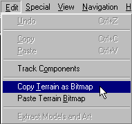
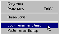
The motives for using this feature have remained obscure until recently (Jan-Mar 2000). To date, the only way it's been used is to copy the terrain altitude from one track to another. Like this: Access the copy terrain as bitmap feature by using one of the following methods:
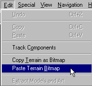
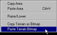
Following either of these procedures will copy the terrain bitmap to the windows clipboard. Next, start a new track or open a track you have been working on and paste the new terrain by using one of these methods:
Voila. The terrain for your track is exactly the same as the one you just copied from.
Two additional techniques have been revealed that exploit the terrain bitmap in traxx. The first is a way to reproduce exact portions of your track from one location to another. To do this, you would open the bitmap in a paint program and then copy and paste sections of it onto itself. Although I don't know anybody who's tried this trick, it might be an interesting shortcut that allows you to recreate a perfect curve without manually editing the terrain again and again. But, as I mention, I don't know of anyone who's had success doing this. The second trick allows you to place models perfectly on top of ground boxes or other places where you want them elevated over uneven terrain. The idea was first brought to light by ObeOne who suggested that copying the terrain to the clipboard (probably saving it in a paint program as backup) allows you to temporarily flatten the area you're working on so that you can place models with precision. Then, once that's done, you can paste the original back in place, the result being that the models are now suspended over the uneven terrain but with perfect placement. Winterkill adds notes about using this trick for better placement of extended courses too. These are probably the most useful applications for the bitmap feature. Thanks ObeOne and wk. |